45 miles, 3173 feet of climb, 4380 ft max
Today was the ride through
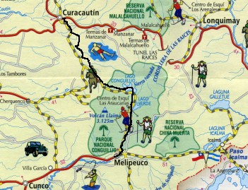
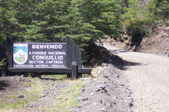
Conguillío
National Park. So far on this trip I have been spoiled by riding on almost all
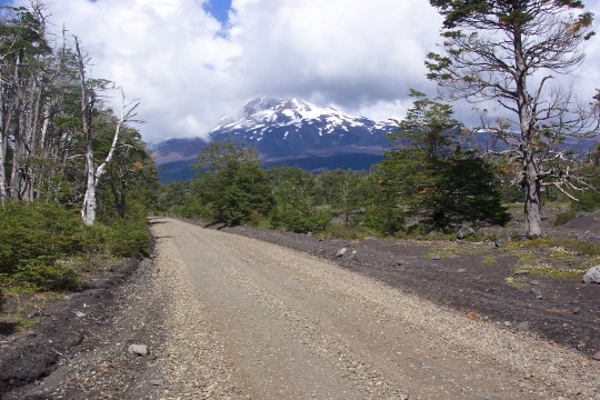
paved roads. Today I was on a very rough dirt road the whole day. The gravel was
loose in most places, forcing me to walk the numerous steep hills because the rear
wheel kept slipping out. On the flat parts, frequent heavy washboarding made it
impossible to go fast. My average speed for the day was 6.5 mph.
 I got a late start this morning, partly due to going to bed late after the long
ride the day before. Besides, looking at the map, I figured the ride today can't
be much over 40 miles. Even if there's lots of climbing it shouldn't take me long.
In fact I didn't make it to Melipeuco until about an hour before sundown.
I got a late start this morning, partly due to going to bed late after the long
ride the day before. Besides, looking at the map, I figured the ride today can't
be much over 40 miles. Even if there's lots of climbing it shouldn't take me long.
In fact I didn't make it to Melipeuco until about an hour before sundown.
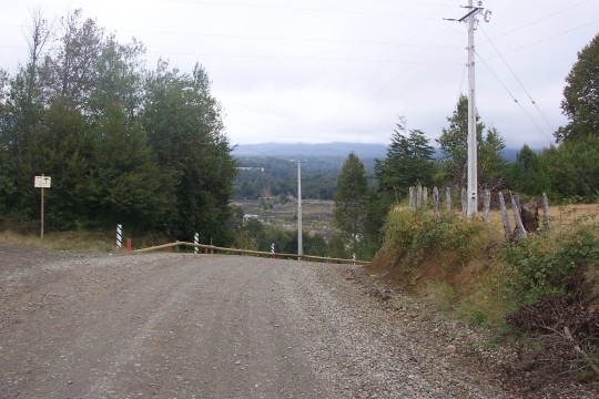
 The road is unpaved right from the edge of town. After an hour or two of riding I
came to an intersection with a well-graded gravel road heading off to the right.
A large sign with a map showed the "Ruta de los Lagos" going in that direction.
It now connects through to Refugio Llaima and Cherquenco, even though my paper map
shows no connection. I decided to keep to the park road since I knew there is
lodging available at the other end in Melipeuco.
The road is unpaved right from the edge of town. After an hour or two of riding I
came to an intersection with a well-graded gravel road heading off to the right.
A large sign with a map showed the "Ruta de los Lagos" going in that direction.
It now connects through to Refugio Llaima and Cherquenco, even though my paper map
shows no connection. I decided to keep to the park road since I knew there is
lodging available at the other end in Melipeuco.
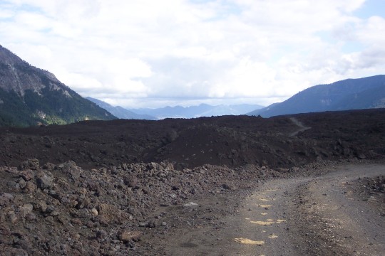
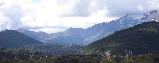
 Not only was the road difficult to ride, but for the first few hours there wasn't
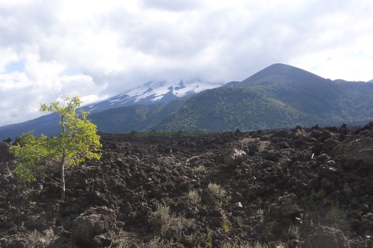
much reward in the way of scenery. Then I suddenly came around a curve and there
was majestic Llaima Volcano with its head in the clouds directly in front of me.
The road got less steep and less gravelly at this point as I proceeded onto the
lava field heading toward the ranger station near the top of the pass.
Not only was the road difficult to ride, but for the first few hours there wasn't
much reward in the way of scenery. Then I suddenly came around a curve and there
was majestic Llaima Volcano with its head in the clouds directly in front of me.
The road got less steep and less gravelly at this point as I proceeded onto the
lava field heading toward the ranger station near the top of the pass.
 When I got to the ranger station there was nobody around. So I sat down at a picnic
table and made myself a lunch of bread and jam. As I was eating, the ranger rode up
on his motorcycle, probably returning from lunch. We exchanged "hola" and he
disappeared into the ranger cabin. In a few minutes he came back out and we had a
fairly long conversation. I was able to understand him quite well. I've found that
I can understand some folks pretty well and others hardly at all.
When I got to the ranger station there was nobody around. So I sat down at a picnic
table and made myself a lunch of bread and jam. As I was eating, the ranger rode up
on his motorcycle, probably returning from lunch. We exchanged "hola" and he
disappeared into the ranger cabin. In a few minutes he came back out and we had a
fairly long conversation. I was able to understand him quite well. I've found that
I can understand some folks pretty well and others hardly at all.
 I showed him my GPS. I was never able to find a detail GPS map for Chile so I have
been using the
Magellan
worldwide base map. It only shows the main highways but it does have topographic
data. By zooming out you could see the volcano very clearly. He wanted to know
the elevation of the ranger station so I paged to the menu where it shows current
elevation in meters. I asked him if it's all downhill from here and he said yes,
except for the next couple kilometers.
I showed him my GPS. I was never able to find a detail GPS map for Chile so I have
been using the
Magellan
worldwide base map. It only shows the main highways but it does have topographic
data. By zooming out you could see the volcano very clearly. He wanted to know
the elevation of the ranger station so I paged to the menu where it shows current
elevation in meters. I asked him if it's all downhill from here and he said yes,
except for the next couple kilometers.
 The next couple kilometers turned out to be the steepest part. I would have had to
walk part of it even if it were paved. Compared to the known 18% grade on the road
I am accustomed to commuting on at home, I estimate this was around 22-25%.
The next couple kilometers turned out to be the steepest part. I would have had to
walk part of it even if it were paved. Compared to the known 18% grade on the road
I am accustomed to commuting on at home, I estimate this was around 22-25%.
 After that it really was nearly all downhill or flat. However, the riding was not
much easier because of the road surface. In places there was heavy washboarding
combined with thick loose gravel which made forward progress extremely difficult.
Apparently it is difficult even for the cars because there were tracks that cars
had worn in the lava field parallel to the official road despite the signs
prohibiting that. Several miles before Melipeuco, the road finally improved to
"normal dirt road" status and I was able to speed up to 8 or 9 mph.
After that it really was nearly all downhill or flat. However, the riding was not
much easier because of the road surface. In places there was heavy washboarding
combined with thick loose gravel which made forward progress extremely difficult.
Apparently it is difficult even for the cars because there were tracks that cars
had worn in the lava field parallel to the official road despite the signs
prohibiting that. Several miles before Melipeuco, the road finally improved to
"normal dirt road" status and I was able to speed up to 8 or 9 mph.
 Just as I was entering town, I noticed a long line of horsemen riding in a big field
to my left. Some were carrying flags on long poles and a bugle was sounding out the
march. It looked like some kind of historical reenactment. Cool! I quickly
stopped and snapped several photos then put the camera away as I continued to watch.
At that point two riders came galloping over to the fence where I was standing.
One of them gave me a severe look and in a stern voice said, "No photos!" I mumbled
that I was sorry and he repeated, "No photos!" I said "OK" (which is Spanish for
"OK") and we went through a couple more rounds of "No photos!" and "OK!"
Just as I was entering town, I noticed a long line of horsemen riding in a big field
to my left. Some were carrying flags on long poles and a bugle was sounding out the
march. It looked like some kind of historical reenactment. Cool! I quickly
stopped and snapped several photos then put the camera away as I continued to watch.
At that point two riders came galloping over to the fence where I was standing.
One of them gave me a severe look and in a stern voice said, "No photos!" I mumbled
that I was sorry and he repeated, "No photos!" I said "OK" (which is Spanish for
"OK") and we went through a couple more rounds of "No photos!" and "OK!"
 I was a little surprised, for two reasons. One is that I didn't think they would
even notice me way over on the other side of a large field. The other is that this
was obviously a public demonstration with crowds watching so I couldn't figure out
why they even cared if I took photos. Later the lady at the hospedaje told me that
it was a Mapuche Indian ceremony. That makes more sense. I've read that the
indigenous people do not like to be photographed. The Mapuche have a long and
proud history. The Spanish were never able to assert control over the area south
of the Bio Bio River and it was not until near the end of the 19th century that the
Chilean army finally conquered them. Even today they have a considerable degree of
autonomy. They seem to have been treated more humanely than other indigenous peoples
in the New World. That's probably because they were able to avoid conquest long
enough until white people became more civilized.
I was a little surprised, for two reasons. One is that I didn't think they would
even notice me way over on the other side of a large field. The other is that this
was obviously a public demonstration with crowds watching so I couldn't figure out
why they even cared if I took photos. Later the lady at the hospedaje told me that
it was a Mapuche Indian ceremony. That makes more sense. I've read that the
indigenous people do not like to be photographed. The Mapuche have a long and
proud history. The Spanish were never able to assert control over the area south
of the Bio Bio River and it was not until near the end of the 19th century that the
Chilean army finally conquered them. Even today they have a considerable degree of
autonomy. They seem to have been treated more humanely than other indigenous peoples
in the New World. That's probably because they were able to avoid conquest long
enough until white people became more civilized.